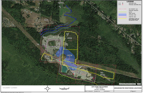
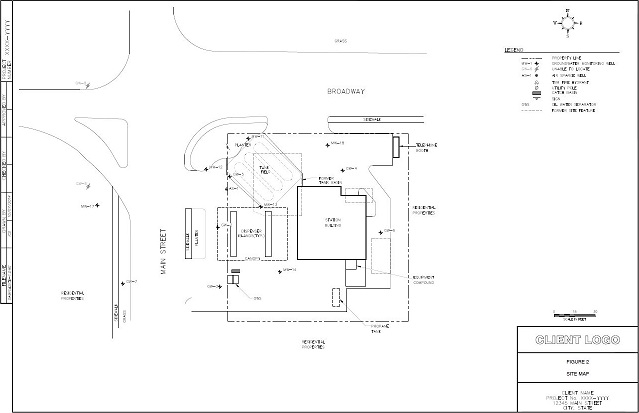
Site Maps are part of Phase I, Phase II Environmental Assessment report, (Phase I / Phase II ESAs), site remediation and monitoring reports. A typical site map includes site features (building, canopy, dispensers, UST field, etc.), sampling points, soil borings and monitoring wells. Site Plans may also include public utilities, historic sampling points, borings, excavations, former site features, etc.
Typically, AutoCAD site maps are created from client sketches, previous consultant CAD files or from a site address, using aerial imagery overlaying site features, utilities, monitoring wells, etc.
All figure requests are made in our cloud-based work management system on a fixed-price basis, and figures are completed within 7 days.
ICD is a technical partner of Inogen, a global corporation providing multinational organisations with consistent, high quality and cost effective environmental, health and safety solutions. With offices located on every continent, more than 2000 staff worldwide, and projects completed in more than 120 countries, Inogen provides for a geographic reach unparalleled in the industry and represents a unique and innovative business model with a single point of contact delivering competitive, cost-effective service around the globe.
All work is managed on a web-based project management site and done on a standard turnaround time for a fixed fee.
LogitEasy offers the following distinct advantages over other programs currently available in industry for drafting boring and well logs:
• Cloud-based application – There are no license fees as with other licensed-based programs; with LogitEasy, you pay only for each borehole logged. Also, users are not required to install new versions. All upgrades to the application are performed in the cloud by the developers of the application, thus ensuring that users always have access to the latest version of the application. LogitEasy can be used both On-line and Off-line.
• User interface mimics traditional field log form – Other currently-available field logging programs rely on database-type user interfaces that do not provide users the vertical borehole profile that they are accustomed to seeing on paper field forms.
• Data-entry sequence based on ASTM standard – The database-type user interfaces in other field logging programs are not based on any standard data entry sequence. With LogitEasy, the data entry workflow is based on an industry-recognized standard and this workflow is applied to each lithologic description; this serves to improve the quality of the logged information and to increase logging consistency between different employees within the same organization.
In addition, the initial boring/well construction information from www.logiteasy.com can be exported to EXCEL and used to:
• develop bid specifications for drilling subcontractors,
• communicate field work scopes to employees,
• prepopulate EXCEL field forms.
If you would like to sign up to use our services, please complete the below form and we will e-mail you a password to the ICD SERVICES Workspace (web portal)
which will enable you to place, track, and pick up orders.
Sign up does not require a credit card or other payment as our services are priced on a pay-as-you-go basis.
Passwords are issued subject to review and approval by ICD SERVICES.
Please contact us if you have any questions about Sign up.
Thank you for requesting sign up to ICD Services! Upon review and approval of your request, you will receive an email with login instructions.